Geothermal
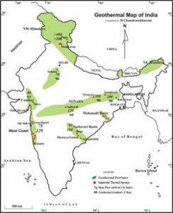
The Geological Survey of India has identified about 340 geothermal hot springs in the country, most of which are in the low surface temperature range from 37oC - 90oC, making them suitable for direct heat applications. These springs are grouped into seven geothermal provinces i.e. Himalayan (Puga, Chhumathang), Sahara valley, Cambay basin, Son-Narmada-Tapi (SONATA) lineament belt, West Coast, Godavari basin and Mahanadi basin. Some of the prominent geothermal resources include Puga valley and Chhumathang in Jammu and Kashmir, Manikaran in Himachal Pradesh, Jalgaon in Maharashtra, Tapovan in Uttarakhand and Tattapani in Chhattisgarh.
Table showing the temperatures, heat flow values and geothermal gradients of the provinces with geothermal potential
| Province | Surface ToC | Reservoir ToC | Heat Flow : mW/m2 | Thermal gradient: oC/km |
|---|---|---|---|---|
| Himalaya | >90 | 260 | 468 | 100 |
| Cambay | 40-90 | 150-175 | 80-93 | 70 |
| West coast | 46-72 | 102-137 | 75-129 | 47-59 |
| SONATA | 60-95 | 105-217 | 120-290 | 60-90 |
| Godavari | 50-60 | 175-215 | 93-104 | 60 |
(Source: Department of Earth Sciences, IIT Bombay)
(Source: Department of Earth Sciences, IIT Bombay)
Map showing Indian geothermal provinces with heat flow and geothermal gradients